GIB FT
Real time tracking of torpedo and UAV for test, trial and training
- Easily deployable
- Low costs compared to fixed bottom-mounted tracking ranges
- Weapons testing in varied subsea environmental conditions
GIB FT
Real time tracking of torpedo and UAV for test, trial and training
- Easily deployable
- Low costs compared to fixed bottom-mounted tracking ranges
- Weapons testing in varied subsea environmental conditions
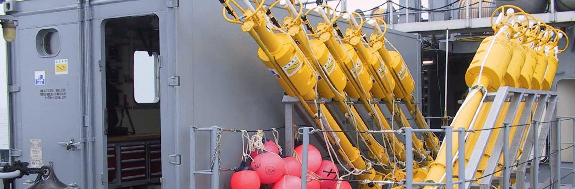
The GIB FT is a Portable Torpedo and UUV tracking range. The GIB-FT system is composed of a set of buoys that receives acoustic signals transmitted by the pingers mounted on the torpedo and the target. The buoys thus measure the distances to the underwater vehicle and periodically transmit, through a local radio network, their GPS position and the measured distances to a Control & Display Unit installed on a support ship or at shore. This Control & Display Unit triangulates the underwater vehicle’s positions & displays it over a chart.
Specifications
6 m
800 mm
60 kg dry (set of 12 buoys) add 3 kg Control command
Acoustic
50 knots
GPS
RF, Iridium
Simultaneous multiple-trackings on the same graphical interface (underwater, surface and air vehicles) Wide tracking range (up to 100 km² with 12 buoys) with a metric accuracy in 3D in the whole coverage area
Real-time data are overlapped on a Jeppesen digitalvector chart supplied
Battery
20-600 m
8 h
Use by DCNS to qualify their new torpedo program, French MoD for torpedo training, German Federal Office of Defense since 2012 for torpedo and UUV qualification
Applications
- UUV & UAV test and qualification
- Torpedo test and qualification
- Training
Key Benefits
- The system’s supervision covers Air, Surface and Underwater layers
- Simultaneous multiple-tracking on the same graphic interface (underwater, surface and air vehicles)
- Wide tracking range: up to 100 km² with 12 buoys
- Shallow to deep waters (20 to 600 m water depth)
- Real-time data is overlapped on a Jeppesen digital vector chart supplied
- Raw data is stored for archival and off-line post processing (analysis and reporting)
- 3D Metric accuracy for the whole area coverage
- Fast buoy deployment and recovery
- No calibration